What it is
Fire weather is weather that makes wildland fire start easily and spread fast. The Weather Service's word for its worst days is critical: fuel dry enough to burn, air dry enough to keep drying it, and wind strong enough to drive the fire, together over country that can burn. On those days it flies the red flag.
It is three things at once. The fuel is the part that builds slowly, over weeks and months of heat and little rain. The air is the part that changes by the hour: its dryness, its wind, its stability. And the spark: most wildfires in the United States are started by people, and the rest by lightning, most dangerously lightning from storms whose rain dries up before it reaches the ground.
Firefighters teach fire behaviour as a triangle of fuel, weather and topography. This plate is the weather side of it.
What it is not
Fire weather is not fire danger. Fire danger is the rating the land management agencies publish, from low to extreme, for how easily fires will start and how hard they will be to control. It is built from the same weather and the same fuel, and it is the agencies' tool. The Red Flag Warning is the Weather Service's.
It is not the same as heat. A hot, humid, still day dries little. A cool, dry, windy day after a dry month can be critical.
It is not the fire itself. Once a fire is large it makes its own weather: a plume of heated air that can grow into a pyrocumulus cloud, or a thunderstorm, Pyroconvection FB-EVT-141. That fire is driven by its own heat, not by the wind, and it behaves differently.
Lookalikes
- Fire danger
- The rating the land agencies publish for how easily fires will start and spread on a given day. It is built from the same weather and fuel, and it is theirs, not a Weather Service warning.
- Dry thunderstorm
- Not a separate storm: a thunderstorm whose rain evaporates in dry air beneath it, so its lightning strikes dry ground. It is one of the red flag criteria.
- Heat
- Heat dries fuel and people, but a hot, humid, calm day is not fire weather.
The machine
The fuel dries toward the air
Dead fuel, the grass, needles, twigs, branches and logs on the ground, trades water with the air around it. It dries when the air is dry and takes on water when it is damp, always moving toward a balance with the air called its equilibrium moisture. How fast it gets there depends on its size. The land agencies class dead fuel by that speed, its timelag: the hours it takes to close about 63 percent of the gap between its own moisture and the air's. Fig. C draws the four classes at half size.
Grass and needles are 1 hour fuels. They follow the air within an afternoon: a dry afternoon dries them, a damp night wets them again. The logs, the 1000 hour fuels, follow the season. A red flag afternoon is dangerous because the fine fuels have dried in hours; a fire season is dangerous because the heavy fuels have dried over months, and a fire that reaches them burns long and hot.
The air's dryness is a deficit
Relative humidity says what fraction of the water vapour the air could hold it is holding. What pulls water out of fuel is the gap: how much more the air could take. That gap is the vapour pressure deficit, and its equation is below. It grows fast with temperature. At the same 15 percent humidity, hot air at 35 °C (95 °F) pulls water from fuel more than three times as hard as cool air at 15 °C (59 °F).
Through a fair day the humidity falls as the temperature rises, and bottoms out in mid afternoon. Fig. B draws one such day. That is when fine fuels are driest and fires run.
The wind and the slope
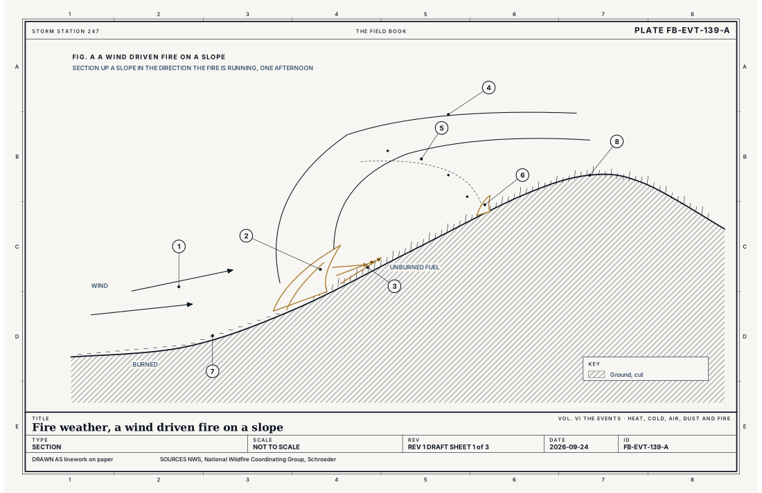
Wind does three things to a fire. It tilts the flame over the fuel ahead, so the fuel is heated and dried before the flame arrives, which is why a wind driven fire spreads so much faster than one in calm air. It feeds the fire air. And it carries embers ahead of the front, sometimes a kilometre or more, where they start new fires, spot fires, that the front then joins. Fig. A draws a fire running up a slope, where the slope tilts the fuel toward the flame as the wind tilts the flame toward the fuel. A fire runs uphill.
The afternoon adds to the wind. As the ground heats, the lowest layer of air mixes deeper, and the mixing brings faster, drier air down from above to the surface. The gusts rise with the temperature, and the humidity falls with both.
Where the worst days come from
The worst fire weather comes with wind that is dry by its nature. Air sinking down a mountain range warms as it is compressed and arrives hot and dry: the Santa Ana of Southern California, the Diablo wind of the Bay Area, the downslope winds east of the Rockies, Santa Ana, Diablo and Sundowner FB-EVT-153. A dry cold front brings a sudden shift of strong wind with no rain. And dry thunderstorms bring lightning to dry ground over large areas at once.
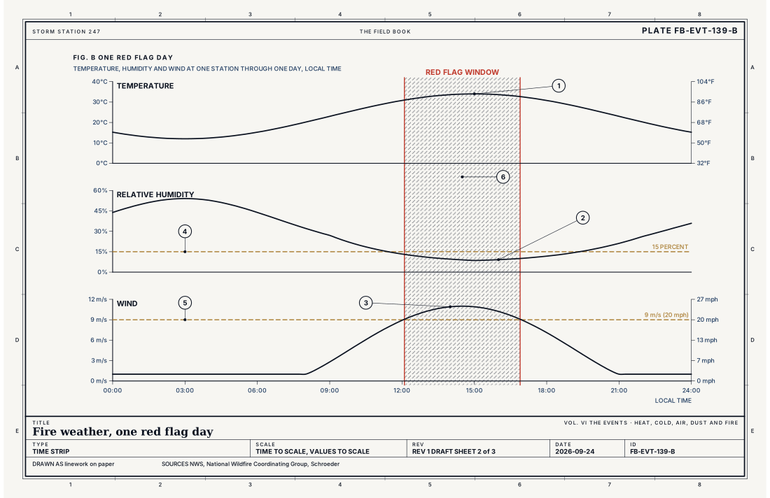
- Temperature
- Relative humidity
- Wind speed
- Humidity at 15 percent
- Wind at 9 m s⁻¹ (20 mph)
- The red flag window
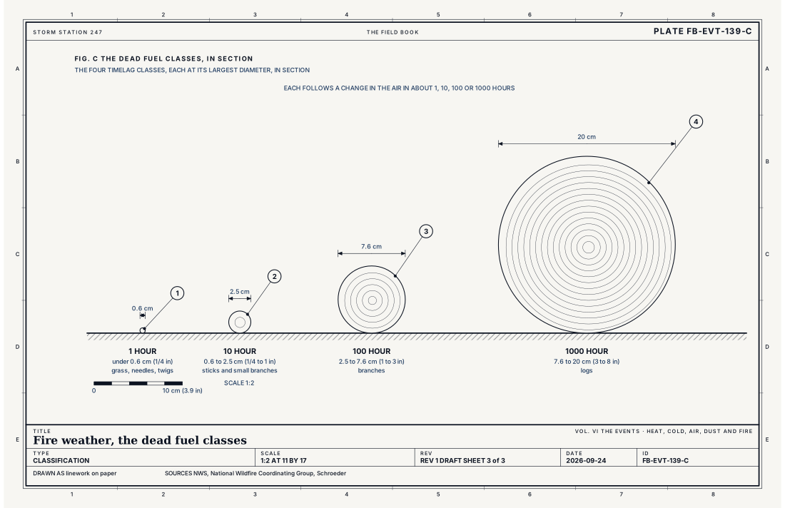
- 1 hour, under 0.6 cm (1/4 in)
- 10 hour, 0.6 to 2.5 cm (1/4 to 1 in)
- 100 hour, 2.5 to 7.6 cm (1 to 3 in)
- 1000 hour, 7.6 to 20 cm (3 to 8 in)
Ingredients
- Dry fuel: grass, needles and twigs that have given up their water to the air, and larger wood dried by weeks without rain
- Dry air: low relative humidity, which on a hot afternoon is a large vapour pressure deficit
- Wind: strong and gusty near the ground, tilting the flame over the fuel ahead and lofting embers
- Instability: a deep, well mixed afternoon layer that brings dry, fast air down from aloft
- Or lightning: thunderstorms whose rain evaporates before it reaches the ground
Scales
- time
- an afternoon, for a red flag day; weeks to months, for the fuel to dry
- horizontal
- a county to a region; one fire, metres to tens of kilometres (feet to tens of miles)
- vertical
- the boundary layer, 1 to 4 km (3,000 to 13,000 ft); a plume dominated fire, the whole troposphere
- orlanski
- meso-beta to synoptic
Equations
The vapour pressure deficit
- how much more water vapour the air could hold, hPa
- the saturation vapour pressure at the air temperature, hPa
- the air temperature, °C
- the relative humidity, percent
Assumes The Magnus form of the saturation vapour pressure over liquid water, accurate to a fraction of a percent between −40 and 50 °C.
Working form At 15 percent humidity, air at 35 °C (95 °F) has a deficit of about 48 hPa, and air at 15 °C (59 °F) about 14.5 hPa: the same humidity, and the hot air pulls water from fuel more than three times as hard.
Signatures
- sounding
- a deep dry adiabatic layer in the afternoon; a large gap between temperature and dew point through it; strong wind at its top
- surface
- humidity falling into the teens or below by afternoon; a rising gusty wind; a wind shift with a dry front or a downslope wind
- satellite
- a hot spot in the shortwave infrared; a smoke plume; a pyrocumulus cap on a large plume
- radar
- a plume of smoke and ash that the radar sees as clear air echo; rising with the fire's heat
The numbers
| Quantity | Value, and the kind of number it is |
|---|---|
| Fire Weather Watch | Critical fire weather is possible, usually 12 to 72 hours aheadStandard, Directive 10-401 |
| Red Flag Warning | Critical fire weather is occurring or will soon, with fuels dry enough to burnStandard, Directive 10-401 |
| Red flag criteria | Set by each office with the land agencies it serves; commonly humidity at or below 15 to 25 percent with sustained wind of 9 m s⁻¹ (20 mph) or more, or dry lightningTypical, Directive 10-401 |
| 1 hour fuels | Dead fuel under 0.6 cm (1/4 in) across: grass, needles, twigsStandard, NWCG Glossary of Wildland Fire (PMS 205) |
| 10 hour fuels | 0.6 to 2.5 cm (1/4 to 1 in)Standard, NWCG Glossary of Wildland Fire (PMS 205) |
| 100 hour fuels | 2.5 to 7.6 cm (1 to 3 in)Standard, NWCG Glossary of Wildland Fire (PMS 205) |
| 1000 hour fuels | 7.6 to 20 cm (3 to 8 in)Standard, NWCG Glossary of Wildland Fire (PMS 205) |
| Timelag | The time a dead fuel takes to lose about 63 percent of the difference between its moisture and the air'sStandard, NWCG Glossary of Wildland Fire (PMS 205) |
| Haines Index | 2 to 6: the stability and dryness of the air above a fire; 5 and 6 favour large, erratic plume growthStandard, NWCG Glossary of Wildland Fire (PMS 205) |
How the station sees it
Fire weather is measured where the fire would be: out in the country, away from towns. Road weather stations along the highways report temperature, humidity and wind, and the airport weather stations report them every minute. The land agencies run their own network of remote fire weather stations for the same reason.
What a forecaster reads from them is the afternoon: how low the humidity will fall, how strong the wind will blow, and whether the two will meet. The temperature layer on the live map is the first half of that picture, analysed from the airport reports across the country. The rest is in the soundings: how deep the afternoon will mix, and how fast the wind is at the top of that mixing.
- Road weather stations: temperature, humidity and wind along the highways
- Airport weather stations: humidity, wind and gusts, every minute
- The temperature layer on the live map: the analysed temperature across the country, from the airport reports
How it is warned
A Fire Weather Watch is issued when critical fire weather is possible, usually 12 to 72 hours ahead. A Red Flag Warning is issued when it is occurring or will soon. The criteria differ from office to office, because fuels and climates differ, and each office sets them with the land agencies it serves: commonly the humidity at or below 15 to 25 percent together with a sustained wind of about 9 m s⁻¹ (20 mph), or dry lightning over dry fuels. The warning names the hours, the humidity and wind expected, and the counties or fire weather zones.
On a red flag day, do nothing that makes a spark: no burning, no mowing of dry grass, no chains dragging from a trailer, no cars parked on dry grass. A fire that starts that day may not be stopped.
| VTEC | Phenomenon | The alerts that carry it |
|---|---|---|
FW | fire weather | Fire Weather Watch; Red Flag Warning |
See also
- Extreme fire weather FB-EVT-140
- Pyroconvection FB-EVT-141
- Santa Ana, Diablo and Sundowner FB-EVT-153
- Fire weather fuels FB-LND-004
- Humidity variables FB-WAT-002
- Thunderstorm FB-EVT-001
- Dense smoke FB-EVT-136
- How to read a warning FB-STN-001
Sources
- National Weather Service. Directive 10-401, Fire Weather Services Product Specification.
- National Wildfire Coordinating Group. NWCG Glossary of Wildland Fire (PMS 205).
- Schroeder, M. J. and C. C. Buck. Fire Weather, Agriculture Handbook 360 (1970).
- Alduchov, O. A. and R. E. Eskridge. Improved Magnus Form Approximation of Saturation Vapor Pressure, Journal of Applied Meteorology 35 (1996).
- American Meteorological Society. Glossary of Meteorology.
Definition after the Directive 10-401, Fire Weather Services Product Specification. Plate FB-EVT-139, revision 1, 2026-09-24. The number is permanent; cite it.