What it is
A warning is a product. The Weather Service issues it in a fixed format, so that a person, a broadcaster, a phone and a machine can each find the same parts in the same places. Read it in order and it answers six questions: what, where, until when, what is happening, what it will do, and what to do.
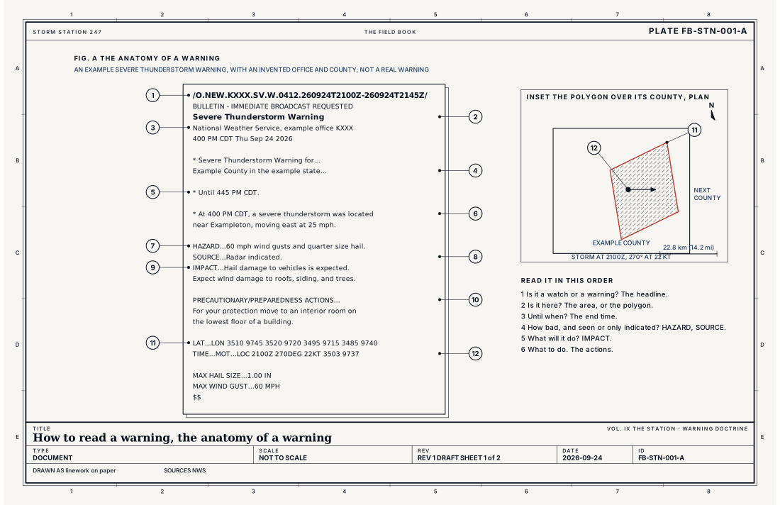
Every alert on this site, from a Tornado Warning to a Frost Advisory, is built the same way. Fig. A numbers the parts on an invented example.
- The headline names the event: a phenomenon, then a significance. Tornado Warning. Flood Watch. Wind Advisory.
- Who issued it, and when, in the local time of the office.
- The area: counties and zones by name, or, for a warning drawn around one storm, a polygon.
- The time it ends. A warning is only in force until then, unless it is extended.
- What is happening: where the storm is and where it is moving. In a storm warning this becomes three tagged lines: HAZARD (what it brings), SOURCE (how it is known: radar indicated, or observed) and IMPACT (what it will do to people and things).
- What to do: the precautionary and preparedness actions.
- The code: a line of VTEC for machines, and for a storm warning the polygon's corners and the storm's motion.
What it is not
A warning is not a forecast. A forecast says what the weather will be. A warning says a hazard to life or property is happening, is about to, or is likely, in this area, until this time.
A watch is not a weaker warning. It is a different product with a different job: it is issued before anything is happening, over a large area and for several hours, when conditions favour the hazard. Its job is to make people ready. The warning is the call to act.
An advisory is not a warning for a smaller place. It is for a less serious hazard: one that causes significant inconvenience, and that could threaten life or property if people are careless. A statement follows up a product in force, or covers a hazard below the others.
A Special Weather Statement is none of these. It carries no VTEC code. Forecasters use it for a storm just below the severe threshold, or for a hazard with no product of its own.
Lookalikes
- Watch
- Not a weaker warning. A watch is issued before anything is happening, for a large area and several hours, so that people are ready when the warning comes.
- Outlook
- A forecast of risk days ahead. It warns of nothing.
- Special Weather Statement
- Carries no VTEC code and no watch or warning. It is used for a storm near the severe threshold, or for a hazard with no product of its own.
The machine
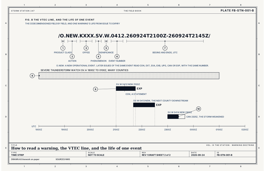
The code is what lets one event be followed from its first issue to its last. The P-VTEC string, drawn dimensioned in Fig. B, reads:
/O.NEW.KXXX.SV.W.0412.260924T2100Z-260924T2145Z/
- O is the product class: operational. T is a test, E experimental.
- NEW is the action. The same event is later CON (continued), EXT (extended in time), EXA (extended in area), EXB (extended in area and time), UPG (upgraded), CAN (cancelled early) or EXP (expired). COR corrects a product and ROU is routine.
- KXXX is the issuing office, four letters. This example's office is invented.
- SV is the phenomenon, severe thunderstorm. The Book's index lists every code.
- W is the significance: W warning, A watch, Y advisory, S statement.
- 0412 is the event tracking number. Each office keeps one series for each phenomenon and significance, begun again each January 1, so the number and the office together name one event for the year.
- The two times are when the event begins and ends, always in UTC.
Flood products carry a second line, the H-VTEC, which names the forecast point on the river, the flood severity (minor, moderate or major), and its immediate cause: excessive rainfall, snowmelt, an ice jam, or a dam or levee failure among them.
The polygon comes after the text. LAT...LON lists its corners in hundredths of a degree. TIME...MOT...LOC gives the time, the direction the storm is moving from in degrees, its speed in knots, and where it was.
The damage threat
Since impact based warnings, a severe thunderstorm warning can carry a damage threat. Considerable means hail of 4.4 cm (1.75 in) or wind of 31 m s⁻¹ (70 mph). Destructive means hail of 7.0 cm (2.75 in) or wind of 36 m s⁻¹ (80 mph), and it sets off a Wireless Emergency Alert on phones in the polygon. A tornado warning's threat can be considerable, and at the top it becomes a Tornado Emergency.
- Product class, O for operational
- Action, NEW for a new event
- Issuing office
- Phenomenon
- Significance
- Event tracking number
- Begins and ends, UTC
- The watch, hours over a large area
- The warning, minutes over a polygon
- The event ends, EXP or CAN
Ingredients
- A hazard: something happening or about to happen that threatens life or property
- A forecaster who has seen it, or a clear signal that it is coming
- A product: the fixed format the Weather Service issues it in, so every reader and every machine can find the same parts in the same places
Scales
- time
- minutes (a storm warning) to days (a winter storm or flood warning)
- horizontal
- a polygon around one storm, or whole counties and zones
- vertical
- not applicable, a warning is drawn on the ground
- orlanski
- not applicable
Signatures
- headline
- the event name; phenomenon then significance; such as Tornado Warning
- code
- the P-VTEC string: /k.aaa.cccc.pp.s.####.yymmddThhnnZ-yymmddThhnnZ/; flood products add an H-VTEC line naming the forecast point, the flood severity and its cause
- text
- the area; the time it ends; HAZARD, SOURCE and IMPACT in a storm warning; precautionary and preparedness actions
- machine
- LAT...LON, the polygon's corners; TIME...MOT...LOC, where the storm was, and how it moves
The numbers
| Quantity | Value, and the kind of number it is |
|---|---|
| Warning | A hazard is occurring, imminent or likely, and threatens life or propertyStandard, Watch |
| Watch | Conditions favour the hazard; its occurrence, place or timing is still uncertainStandard, Watch |
| Advisory | A less serious hazard that causes significant inconvenience, and could threaten life or property without careStandard, Watch |
| Statement | A follow up to a product in force, or information on a hazard below the othersStandard, Watch |
| Storm based warning | Drawn as a polygon around the threat, not whole counties; among them the severe thunderstorm, tornado, flash flood, snow squall, extreme wind and special marine warningsStandard, Directive 10-511 |
| Life of a severe thunderstorm or tornado warning | Commonly 30 to 60 minutesTypical, Directive 10-511 |
| Considerable damage threat | Severe thunderstorm: hail 4.4 cm (1.75 in) or wind 31 m s⁻¹ (70 mph)Standard, Directive 10-511 |
| Destructive damage threat | Severe thunderstorm: hail 7.0 cm (2.75 in) or wind 36 m s⁻¹ (80 mph); sets off the Wireless Emergency Alert on phonesStandard, Directive 10-511 |
| VTEC times | Always Coordinated Universal Time (UTC), written yymmddThhnnZStandard, Directive 10-1703 |
| Event tracking number | Four digits, one series for each office, phenomenon and significance, begun again each January 1Standard, Directive 10-1703 |
How the station sees it
The alerts page reads every alert in force from the Weather Service every two minutes. It draws each on the counties it covers, filled for a warning, hatched for a watch, washed for an advisory and outlined for a statement, and draws the polygon of a storm warning over them as a heavy line. The card for each alert prints its headline, when it ends, the area, the severity, urgency and certainty the Weather Service gives it, and the full text with what to do.
What it adds is this book. Each card carries the plates that explain the machine behind its hazard, under "Read the plates", and this plate on every one.
- Every alert in force: each one drawn on the counties it covers, with its full text
- The live map: the alert layer, over the radar
How it is warned
The order of reading is the order of acting. The headline tells whether the product is a watch, to get ready, or a warning, to act. The area tells whether it is you. The end time tells how long. The HAZARD, SOURCE and IMPACT lines tell how bad, and whether it has been seen or only indicated on radar. The actions tell what to do, and they are written by the forecaster for this event.
An expired warning has not always ended the danger. A storm can leave one polygon and enter the next: the next warning is a new event, with a new number, for the area downstream. Read the one in force where you are.
See also
- Watch, warning and advisory FB-STN-004
- Station model FB-STN-002
- Thunderstorm FB-EVT-001
- Flash flood FB-EVT-100
- Coastal flood FB-EVT-105
- Fire weather FB-EVT-139
- Particularly dangerous situation FB-EVT-024
- Tornado emergency FB-EVT-172
Sources
- National Weather Service. Watch, Warning, Advisory definitions.
- National Weather Service. Directive 10-511, WFO Severe Weather Products Specification.
- National Weather Service. Directive 10-1703, Valid Time Event Code (VTEC).
- National Weather Service. Directive 10-922, Weather Forecast Office Hydrologic Products Specification.
- American Meteorological Society. Glossary of Meteorology.
Definition after the Watch, Warning, Advisory definitions. Plate FB-STN-001, revision 1, 2026-09-24. The number is permanent; cite it.